

KSM's Iron Cap Deposit is seen to the center & left. The BC Mining Properties' North Mitchell Property is seen to the center & right
OPTIONED TO DECADE RESOURCES LTD.
NORTH MITCHELL PROPERTY
LOCATION: GOLDEN TRIANGLE, BC
Size: 2380.73 acres (963.45 ha)

The following world-class mineral deposits are located within a few kilometers of the property;
The combined (total) number of ounces of GOLD within 8 deposits situated in 3 directions around the North Mitchell Property (measured, indicated + inferred) is estimated at 201.67 Million Oz+/- as follows:
1.) KSM’s Iron Cap deposit is located within 2 km, with a combined resource of 36.1 Million Oz Au
2.) KSM’s Snowfield deposit is located within 2.9 km, with a combined resource 34.9 Million Oz Au
3.) KSM’s Kerr, Sulphurets, Mitchell deposits, total a combined 88.3 Million Oz Au, located 8.8 km, 5.5 km & 3.6 km from North Mitchel respectively
4.) Tudor Gold’s Treaty Creek deposit is within 4.675 km, with a combined 27.87 Million Oz Au
5.) Newmont’s Brucejack & Valley of Kings deposits are within 6.5 km, with a combined 14.5 Million+ Oz Au (highest grade gold mine in the world)
*These estimates DO NOT include the HUNDREDS of MILLIONS of ounces of silver and BILLIONS of pounds of copper included within these deposits.
Situated in north-central British Columbia, within the Stikine-Terrane and the heart of the Golden Triangle, the North Mitchell Property has potential to host TWO deposit types;
1.) Porphyry - Cu, Au
2.) Epithermal - Au, Ag
On the North Mitchell Property direct evidence for the presence of a mineralizing system is restricted to locally pervasive quartz-sericite-pyrite (QSP) alteration at lower stratigraphic levels and locally associated veining that to date has only returned anomalous gold grades. Mapping, however, has revealed good evidence on the property for the existence of a possible inverted Early Jurassic structure, and this structure is coincident with the most intense alteration. The structure is manifest as a (faulted) mid-Cretaceous fold with a northeasterly trending axial plane across which a gently to moderately northerly-dipping sequence of relatively thin but distinctive volcanic strata on the northwest correlates well with similar but steeply southeastly-dipping to slightly overturned strata on the east that appear to be part of a much thicker sequence than their correlatives to the west. The change in stratigraphic thickness of coeval strata across this strongly southeast-vergent structure may therefore mark the presence of an inverted syn-depositional Early Jurassic structure. Given its association with common QSP alteration of lower Hazelton Group rocks, and given its general spatial association with both the Brucejack trend and with the northeast trend marked by the Au-rich Cu porphyries at Kerr, Sulphurets, Mitchell, and Iron Cap on Seabridge’s property (a trend which includes the emerging Au and Au-Cu systems still farther northeast on Tudor Gold’s Treaty Creek property).
“Although conceptual, the North Mitchell Property target is extremely compelling”
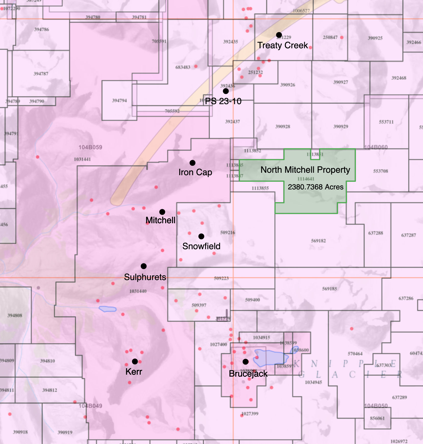
NORTH MITCHELL PROPERTY CLAIM MAP
The North Mitchell Property is situated amongst several of the world’s most significant mineral deposits within the “Golden Triangle” of northwestern British Columbia


1ST DERIVATIVE GEOPHYSICS
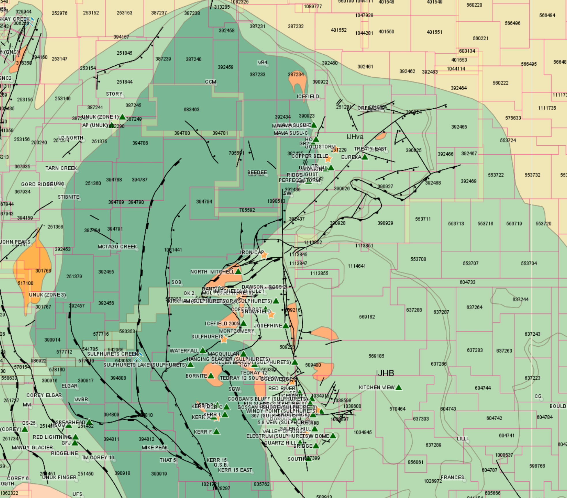
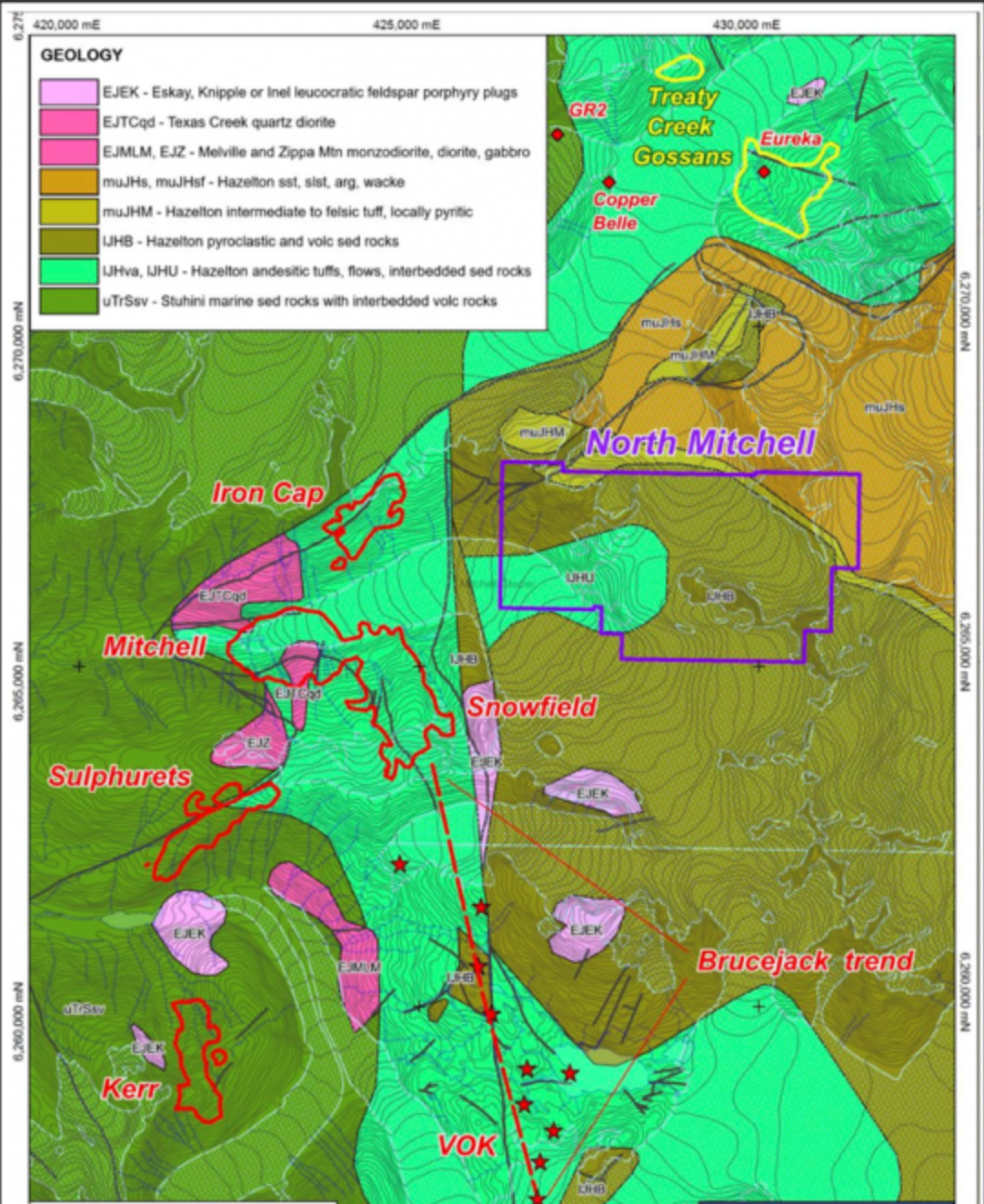
GEOLOGICAL MAPS

SATELLITE PHOTO - August 2023

North Mitchell Property
BC Mining Properties North Mitchell Property consists of a single tenure comprising 963.45 hectares situated in “Elephant Country,” and 2 km east-southeast of Seabridge Gold’s porphyry Au-Cu deposit, Iron Cap, and a similar distance across the Mitchell glacier from KSM’s Snowfield gold deposit. Recent mapping of the property has confirmed that the same stratigraphic units which host many of the occurrences on Newmont’s Brucejack property (6.5km south) track across and are preserved at North Mitchell. This is significant because many of the occurrences at Brucejack, which are aligned along a North x NE trend that runs from south of the Valley of the Kings (Brucejack deposit) north at least as far as the Snowfield deposit, occur at, or near, a similar stratigraphic level within the Early Jurassic section. Along that trend, intrusive and host stratified rocks below that stratigraphic level are commonly much more altered than the rocks above. This is particularly so near discordant structures (faults) which cut the host rocks and appear to have acted as controls for mineralization and alteration along the trend, but commonly at high angles to it. As has been shown at Brucejack, these faults also appear to have acted as basin-bounding extensional structures during deposition of the Early Jurassic volcanic and associated clastic rocks. In the Sulphurets Camp, these discordant structures may also have been reactivated and locally inverted much later, during contractional deformation associated with development of Skeena fold belt in mid-Cretaceous time. Examples of such inverted structures in the Camp probably include the Sulphurets and Mitchell thrust faults, as well as folds at various scales, including the Valley of Kings syncline along Brucejack trend, and folds and faults running sub-parallel to the trends of the Sulphurets and Mitchell thrusts.
On the North Mitchell Block direct evidence for the presence of a mineralizing system is restricted to locally pervasive quartz-sericite-pyrite (qsp) alteration at lower stratigraphic levels and locally associated veining that to date has only returned anomalous gold grades. Our mapping, however, has revealed good evidence on the property for the existence of a possible inverted Early Jurassic structure, and this structure is coincident with the most intense alteration. The structure is manifest as a (faulted) mid-Cretaceous fold with a northeasterly trending axial plane across which a gently to moderately northerly-dipping sequence of relatively thin but distinctive volcanic strata on the northwest correlates well with similar but steeply southeasterly-dipping to slightly overturned strata on the east that appear to be part of a much thicker sequence than their correlatives to the west. The change in stratigraphic thickness of coeval strata across this strongly southeasterly vergent structure may therefore mark the presence of an inverted syn-depositional, Early Jurassic structure. Given its association with common QSP (quartz-sericite-pyrite) alteration of lower Hazelton Group rocks, and given its general spatial association with both the Brucejack trend and with the northeast trend marked by the Au-rich Cu porphyries at Kerr, Sulphurets, Mitchell, and Iron Cap on Seabridge’s property (a trend which includes the rapidly emerging Au and Au-Cu system on Tudor Gold’s Treaty Creek property). Conceptually, the North Mitchell target is extremely compelling.
A number of approaches should be considered to help refine targets for drilling at North Mitchell, including further geologic mapping, and a Magnetotelluric or deep-looking IP Survey. In 2020, a single BLEG (Bulk Leachable Extractable Gold) sampling was undertaken on the North Mitchell Property which returned anomalous levels of Au (27.64 ppb).
BLEG SAMPLING
Bulk Leach Extractable Gold sampling is a geochemical technique used in mineral exploration to detect low levels of gold in large volumes of soil sediment. The method involves collecting large samples, typically in the range of 2 - 5 kilograms from stream sediments, soils or other surficial materials. These samples are then processed to extract gold and other trace elements.


In a 2018 presentation (pages 8, 33-34), Eskay Mining reported that the same stratigraphic units hosting numerous occurrences on Newmont’s Brucejack property are also present at the North Mitchell Property. Local, pervasive Quartz-Sericite-Pyrite (QSP) alteration is observed at lower stratigraphic levels, associated with veining that has so far yielded only anomalous gold values. The presence of common QSP alteration in the lower Hazelton Group rocks, along with its spatial association with both the Brucejack trend and the northeast trend marked by the Au-rich Cu porphyries at Kerr, Sulphurets, Snowfield, Mitchell, and Iron Cap on Seabridge’s property to the west, including Tudor Gold’s Goldstorm deposit 4.8 km to the north, makes this conceptual target (see picture above) extremely compelling.


Iron Cap Deposit Mineral Resources as of January 2024 (Source: Seabridge Gold)
Attention should be given to the locations #1 - #6 plotted on the Total Magnetic Intensity Map and how they correlate to the immediate two Google Earth Maps above
NOTE: These locations are referenced at 11:40 in the deep-dive audio conversation also linked near the top of the page
Specifically, locations #2, #3, #4 are compelling when compared to the magnetics at or near Tudor Gold’s Gold Storm deposit
FYI: Location #1 is plotted on 425000E 6249000N as a point of reference only

An overlay of Tudor Gold’s Total Magnetic Intensity Map (above) onto Google Earth

In a 2010 exploration program that partially covering the North Mitchell Property, 9 samples were taken from an area of approximately 350m x 160m located predominately on the west side of the property. The results were inconclusive and no assays were provided. They were however stated to be generally anomalous.
2010 Exploration on the North Mitchell Property Report (Pages 50 - 55)
CONCLUSION
“Pyritization found on the Mitchell Glacier Claims (North Mitchell Property) may represent a higher more peripheral phase of mineralization than that found to the west of the Brucejack fault on Silver Standard Ltd.’s ground” (KSM’s - Iron Cap Deposit).
https://eskaymining.com/site/assets/files/3718/eskaymining_2010_eskay_exploration_progress.pdf (original file)


Perfectstorm Zone (PSZ or PS)
Tudor Gold’s 30M+/- oz Treaty Creek deposit is an emerging elephant.
In 2023 Tudor stepped out to the South of their main Goldstorm deposit to drill 3 holes in an area they named the Perfectstorm Zone where drill holes PS-23-07, PS-23-08, PS-23-09 & PS-23-10 were placed. All holes intersected meaningful Au, Ag, and Cu mineralization. Most importantly, drill-hole PS-23-10, drilled to 666m depth, oriented to a 170-degree azimuth and a -60-degree dip, (for all intents is pointing south toward the North Mitchell Property).
This is the description of the drill-hole copied from a October 31st, 2023 News Release:
PS-23-10: Drilled at a relatively shallow dip to the south to explore for extension of the mineralized zone encountered in drill hole PS-23-07. This hole intersected 102.15 m of 1.28 g/t AuEQ (1.23 g/t Au, 3.43 g/t Ag, 0.01 % Cu) including two enriched zones comprising 42.5m of 1.87 g/t AuEQ (1.80 g/t Au, 5.76 g/t Ag, 0.02 % Cu), and 25.5 m of 1.60 g/t AuEQ (1.58 g/t Au, 1.81 g/t Ag, 0.01 % Cu). Further downhole a high-grade vein zone was intersected and returned 1.5 m of 24.70 g/t gold. These results are the highest gold grades seen at PSZ to date and they are located between the Goldstorm Deposit, 3 km to the northeast, and Seabridge Gold’s Iron-Cap Deposit, 2.5 km to the southwest.
With that said, and although the Treaty Creek/Goldstorm Deposit Minfile is noted as being 4.65km North of the North Mitchell Property, the fact is meaningful (ore-grade) mineralization is present and proven less than 2.6 km from the edge of the North Mitchell Property (52% closer) and is open to depth and direction (S) toward North Mitchell. To put this into perspective, if the mineralized area around PS-23-10 equated to a conservative 500m x 500m foot print with the following grade and interval, it could be calculated like this; 500m x 500m x 102.15m x 2.8 kg/m3 x 1.28 gpt AuEq = 91,526,400 grams Au = 2,942,687 ounces of AuEq (just shy of 3 Million Ounces). Welcome to Elephant Country!


Cross-section through the SW Perfectstorm Zone showing down-plunge intensification of gold grades within a continuous shear-controlled system, with the deepest high-grade intercept in PS-23-10 defining a southeast-directed vector consistent with extension toward the North Mitchell area.


1991 Mapping done by BC Ministry of Energy & Mines (below)

Three instances of (py) pyrite are noted in a 1991, BC Ministry of Energy & Mines mapping program that covered much of what was exposed on the North Mitchell Property 33 years ago. Based on the average glacial melt since 1991, you can safely assume much more ground has been exposed since that time.
Google Earth images highlight the indicated showings (mapped above) along with several other highly-prospective “Areas of Interest” (shown below).


NORTH MITCHELL PROPERTY