
BC Mining Properties is a privately owned mineral property and exploration company focused in
British Columbia, Canada
BC Mining Properties is committed to advancing several mining projects including our MAC (Mo-Cu + Ni) Property in North-Central BC located contiguous to FPX Nickel who are rapidly advancing the Baptiste (Decar) Nickel Deposit.
Other key properties include the North Mitchell Property located in the heart of the Golden Triangle, the Bonaparte Gold Property, located 50 km North of Kamloops, the Omineca/Abe Porphyry Prospect and the May & Jennie Gold Property located on two mineral leases near the city of Nelson, BC..
Several properties are available for Option or Sale and are accessible via air transportation from the cities of Prince George, Terrace, Kamloops and Trail, BC.
BC Mining Properties (802213 Alberta Ltd.) has active Option Agreements with New Gold., Decade Resources, Sasquatch Resources, First Atlantic Nickel, Nova Pacific Metals, Red Eye Resources, Cariboo Rose Resources and Molymac Mining Corp..
Properties
1.) North Mitchell Property - Au Epithermal + Au-Cu Porphyry - Optioned
2.) MAC Mo/Cu Property - Optioned
3.) MAC Nickel Property - Available
4.) Bonaparte Au + Au/Cu Porphyry - Optioned
5.) May & Jennie Gold - Available
6.) Omineca Abe Cu/Au Porphyry - Available
7.) Thunder Copper Cu/Au Porphyry - Available
8.) Vic Gold - Available
9.) Bren / Keno Cu-Au Porphyry - Available
10.) Empress Jade Prospect - Dease Lake - Highway access - Available
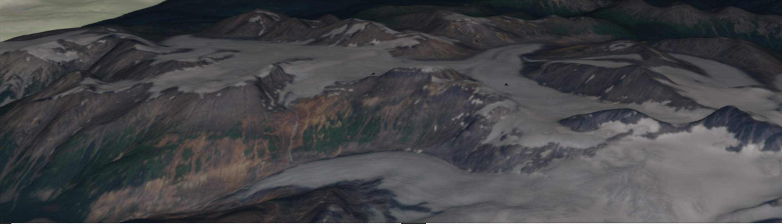
NORTH MITCHELL PROPERTY
The coexistence of bonanza-grade epithermal gold–silver mineralization and emerging copper–gold porphyry indicators within the same structural footprint positions North Mitchell as a rare, vertically integrated discovery opportunity with true district-scale upside.
DEPOSIT TYPES - (Au) Epithermal + (Cu/Au) Porphyry
LOCATION
THE HEART OF THE GOLDEN TRIANGLE
SIZE: 2380.73 acres (963.45ha)
OWNERSHIP
DECADE RESOURCES LTD. - Option to acquire a 70% Interest
802213 Alberta Ltd - retains a 30% carried interest
RECENT NEWS Dec. 04, 2025
Decade Resources reports BONANZA GRADE assay from sample taken from the North Mitchell Property:
116.9 gpt Gold, 161 gpt Silver, 3.01 % Lead and 5.6 % Zinc
The North Mitchell Discovery
Think About This…
The North Mitchell Property sits squarely in the heart of Elephant Country, surrounded on three sides by world-class gold, silver, and copper endowment and positioned within the same district-scale magmatic–hydrothermal plumbing system that hosts the Brucejack Mine to the south, the Iron Cap Deposit to the west, and the Treaty Creek Deposit to the north. These deposits represent different vertical expressions of a common mineralizing system—Brucejack as a high-grade epithermal gold deposit, Iron Cap as a gold-rich Cu–Au porphyry, and Treaty Creek as a large Au–Cu porphyry system with internal zoning and local epithermal-style overprints—all linked by a dominant north–south fault corridor that focused fluid flow across the district.
At North Mitchell, Decade Resources has confirmed bonanza-grade epithermal mineralization, highlighted by a grab sample assaying 116 g/t Au, 161 g/t Ag, 3.01% Pb, and 5.6% Zn. In addition, a separate sample described as chalcocite with visible bornite is currently awaiting assay; if confirmed, it would represent direct evidence of copper–gold porphyry-style mineralization within the same structural footprint. The convergence of high-grade epithermal mineralization and emerging porphyry indicators strongly supports the interpretation of a large, vertically integrated magmatic–hydrothermal system, materially expanding the project’s scale, depth potential, and discovery upside. These results position North Mitchell to advance beyond a standalone epithermal target toward a district-scale epithermal gold and Cu–Au porphyry discovery, comparable in geological setting and strategic importance to its world-class neighbours.
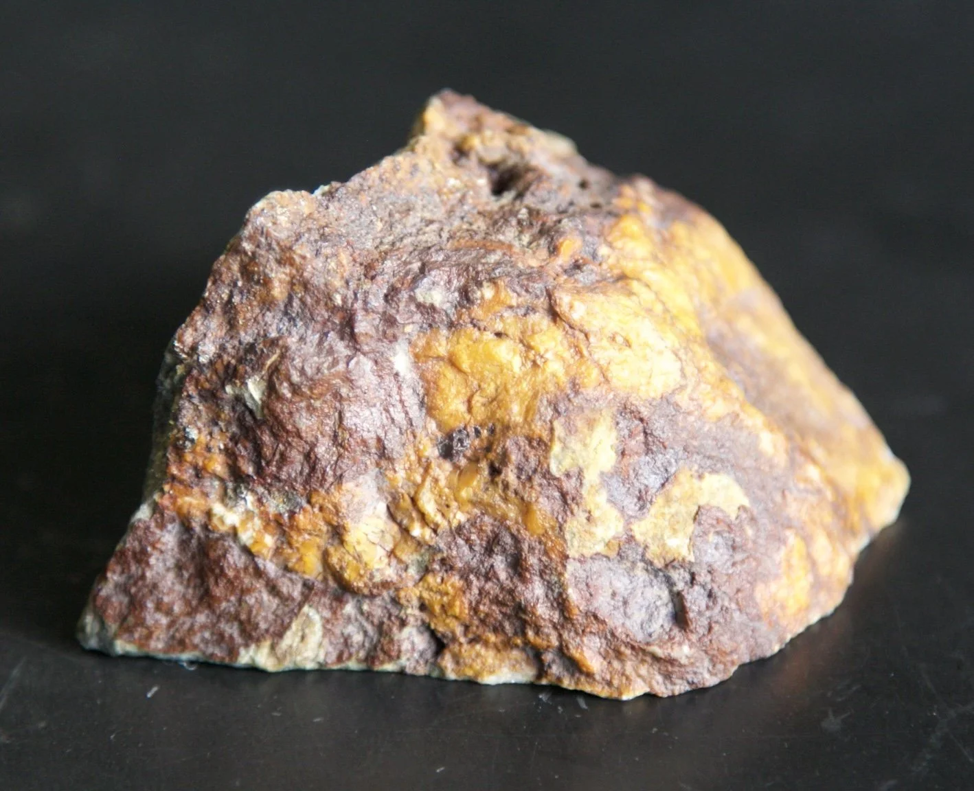
High-Grade Epithermal Mineralization Confirmed
Below: Are 4 close-up pictures of an epithermal vein breccia sample from the North Mitchell Property, showing quartz–carbonate veining, vuggy textures, and iron-oxide stained sulphide cavities typical of high-temperature hydrothermal systems.
This sample, taken from the same corridor that hosts Brucejack (6.5 km south), Iron Cap 2 km west) and Treaty Creek (to the north), represents the first verified high-grade surface expression of the mineralizing system believed to underlie the North Mitchell Property.
Its texture, mineral assemblage, and assay chemistry strongly suggest a gold–silver–zinc–lead epithermal phase directly linked to deeper Cu–Au porphyry fluids, reinforcing the interpretation of a telescoped dual deposit system.
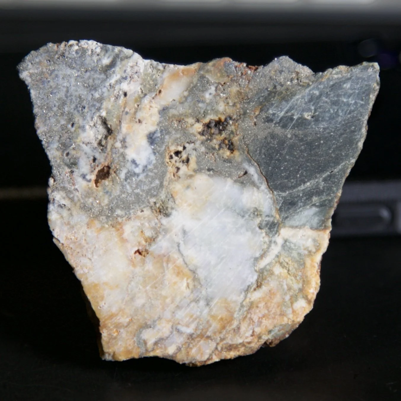
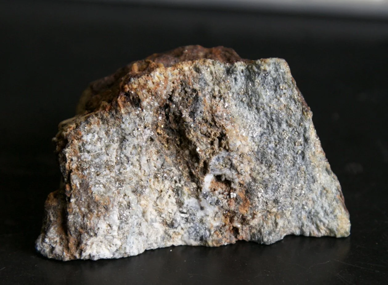
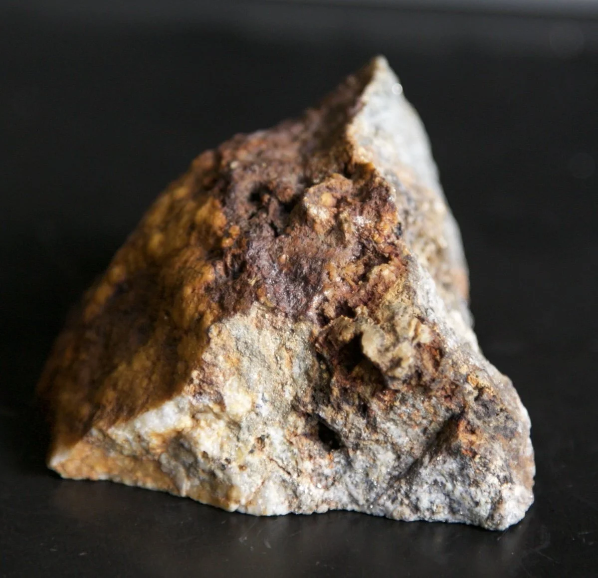
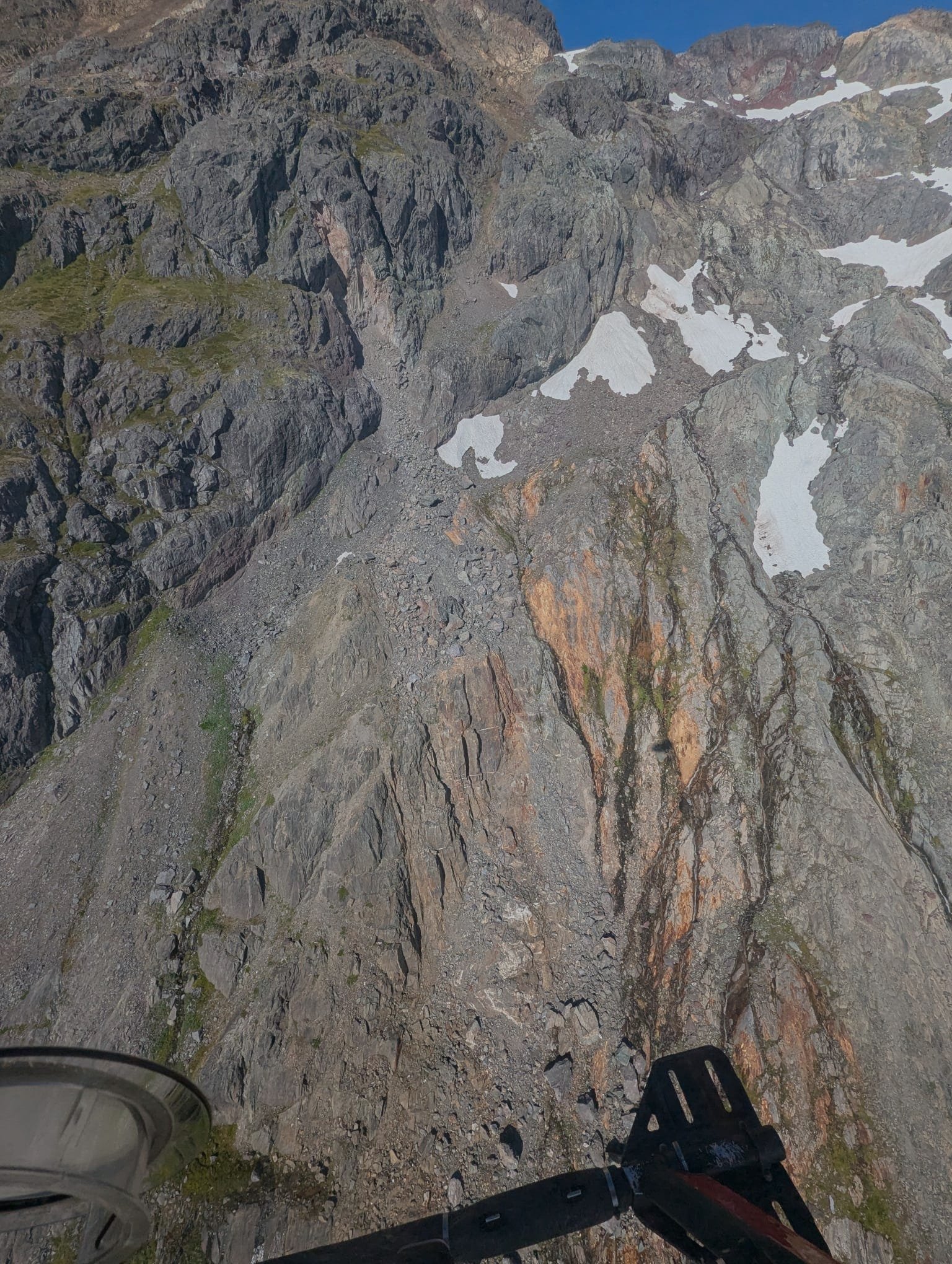
North Mitchell Property Pictures


The North Mitchell Property contains the rocks and geology necessary to host porphyry copper-gold and epithermal gold mineralization. The property is located in north-central British Columbia within the Stikine Terrane, the locale for seven WORLD-CLASS deposits, underlain by similar lithologic units hosting these deposits and is currently one of the most exciting mineral properties being explored in British Columbia. Decade Resources Ltd. holds an Option to acquire a 70% interest in the property.
*200 Million Ounces Gold +++
*The values below are for GOLD only and do NOT include the HUNDREDS of Millions of ounces of Silver and BILLIONS of pounds of Copper within these deposits.
KSM’s 34M oz Au +/- Iron Cap Deposit - situated 2 km west of the North Mitchell Property.
KSM’s 25.9M oz Au +/- Snowfield Deposit - located less than 2.9 km southwest of North Mitchell.
KSM’s 88.3M oz Au +/- KSM (Kerr, Sulphurets, Mitchell) Deposits (combined) are situated 8.8 km, 5.6 km & 3.6 km respectively from North Mitchell.
Newmont’s 32M oz Au +/- Brucejack Deposit, considered to be one of the highest-grade gold mines in the world, is located 6.5 km south of the N. Mitchell Property. (Resource World)
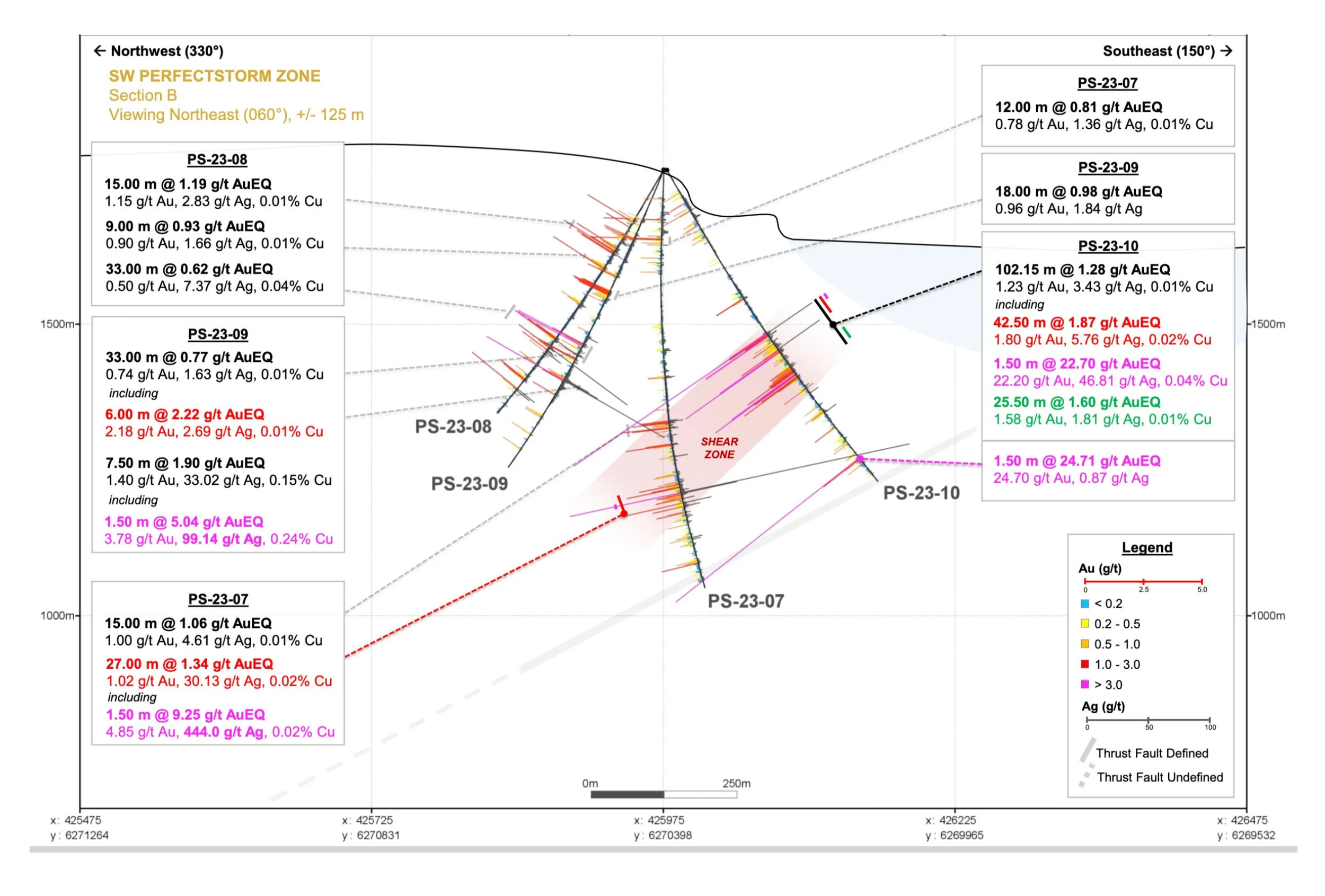
Tudor Gold’s 27.87M Au oz +/- Treaty Creek Deposit - 4.675 km north of N. Mitchell. In 2023, an ore-grade drill intersection (PS-23-10) ended in mineralization within 2.6 km of North Mitchell. (Also See: North Mitchell page)
Tudor Gold’s PS-23-10 drill hole is widely cited for its 102.15 metres of 1.28 g/t AuEq, confirming a broad gold-bearing system within the Perfectstorm Zone. Of particular geological significance, however, is the 1.5-metre interval grading 24.70 g/t gold encountered at the bottom of the hole, the highest gold grade reported at Perfectstorm to date. As illustrated (immediately below) in two cross-sections produced by Tudor Gold, this high-grade interval occurs within a well-defined shear zone and lies down-plunge of earlier intercepts, indicating focused structural fluid flow and vertical upgrading at depth rather than simple lateral continuity within a disseminated envelope. The geometry of PS-23-10 and the distribution of high-grade intercepts define a clear down-plunge vector along the controlling structure, consistent with extension toward the North Mitchell area. The fact that this high-grade zone remains open downhole confirms that the system is not vertically exhausted and reinforces the interpretation of a vertically extensive, feeder-controlled gold system at the district scale.

Claims Map (above) depicting the locations of seven (7) world-class deposits along three sides of the North Mitchell Property.

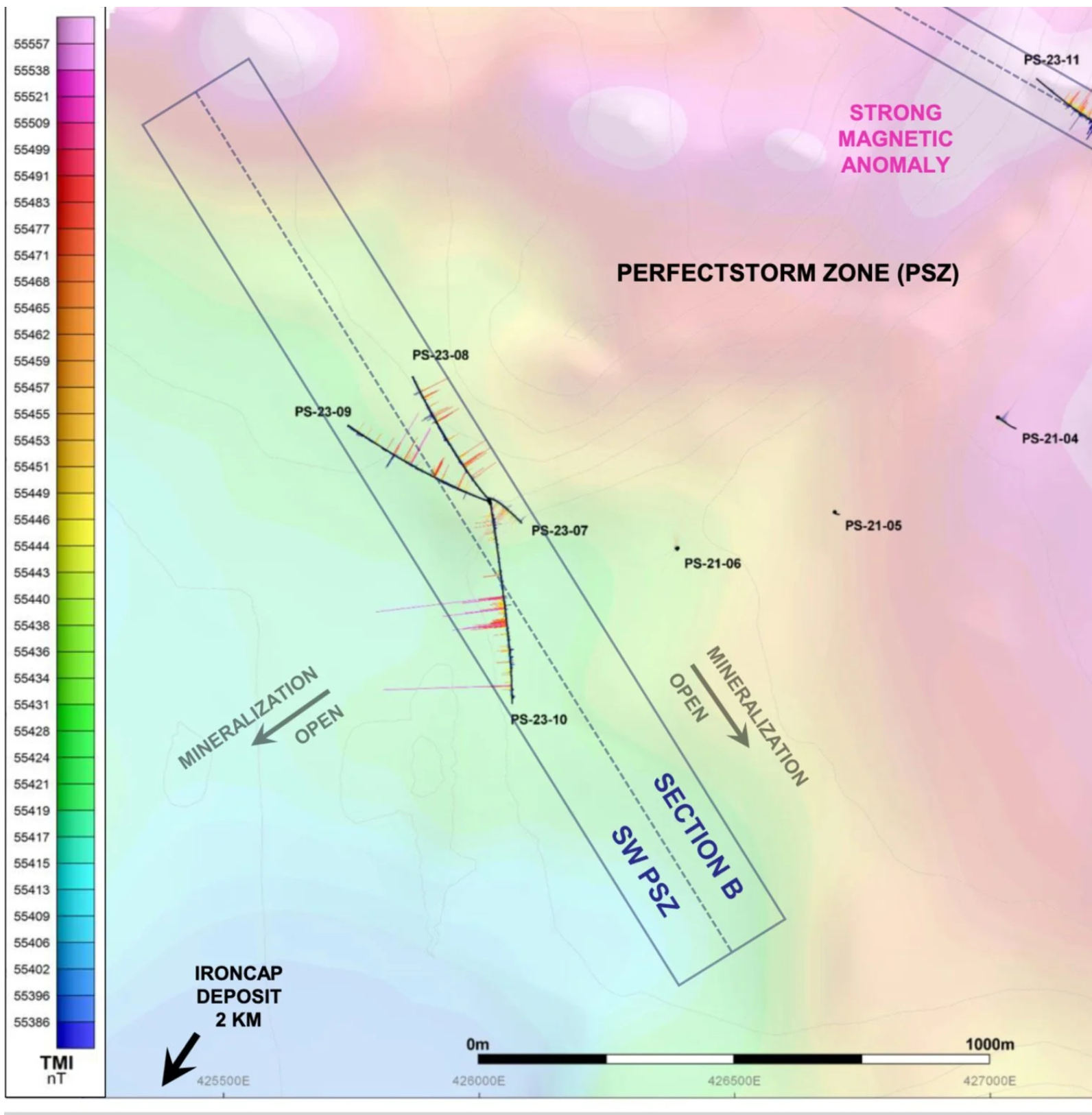
Above is a First Derivative Magnetics Map depicting a possible convergence area of Epithermal and Porphyry mineralization at or near the North Mitchell Property (PS 22-10 should say PS 23-10).


THE MAC PROPERTIES
The MAC Properties are a double-edged sword. The MAC Mo/Cu (East side) contains an advanced - 248,294 kt Mo/Cu Porphyry Deposit containing a combined Indicated + inferred 262,456,071 pounds of Molybdenum and 319,917,056 pounds Copper. In-situ value of the Molybdenum is $11.81B CAD and the contained Copper is $2.16B CAD. Total Value = $13.97 Billion Dollars CAD (Sept 30, 2025). The MAC Molybdenum-Copper Property has been Optioned to Colossal Strategic Minerals Inc.

MAC Nickel - Brief History
In 2012, highly anomalous levels of ultramafic rocks hosting visual awaruite nickel and chrome were discovered on the Mac Property across a substantial strike length.
In 2021, nickel-bearing zones spanning across the property along a northwest-trending magnetic feature in ultramafic rocks covering an area of approximately 5620 ha (13,887 acres) and a strike length of over 16 km. Rock samples returned values up to 0.37% Nickel, 0.32% Chromium, and 150 ppm Cobalt with 138 of the 177 samples returning over 0.1% Nickel and 123 of the 177 samples returning over 0.1% Chromium.
In August 2023, of 57 rock samples collected on the Mac Nickel claims, nineteen (19) returned assays above 2000 ppm (0.2% Ni), with a high of 2600 ppm (0.26%). Another sample recorded 26.3% Magnesium, while 18 others recorded levels greater than >23% Mg. All samples exceeding a 2000 ppm (0.2%) Ni threshold also displayed anomalous levels of Cobalt to 140 ppm (0.014%), and Chrome to 2211 ppm (0.221%), solidly reinforcing the potential for multi-element mineral deposits.
In August 2024, two small MMI (Mobile Metal Ion) grids were sampled on the southern Mac Nickel Claims, yielding significant results for Nickel, Magnesium, Cobalt, Molybdenum & Copper. Follow the Results Link below:
2024 MMI Results - Link
Also see Reports
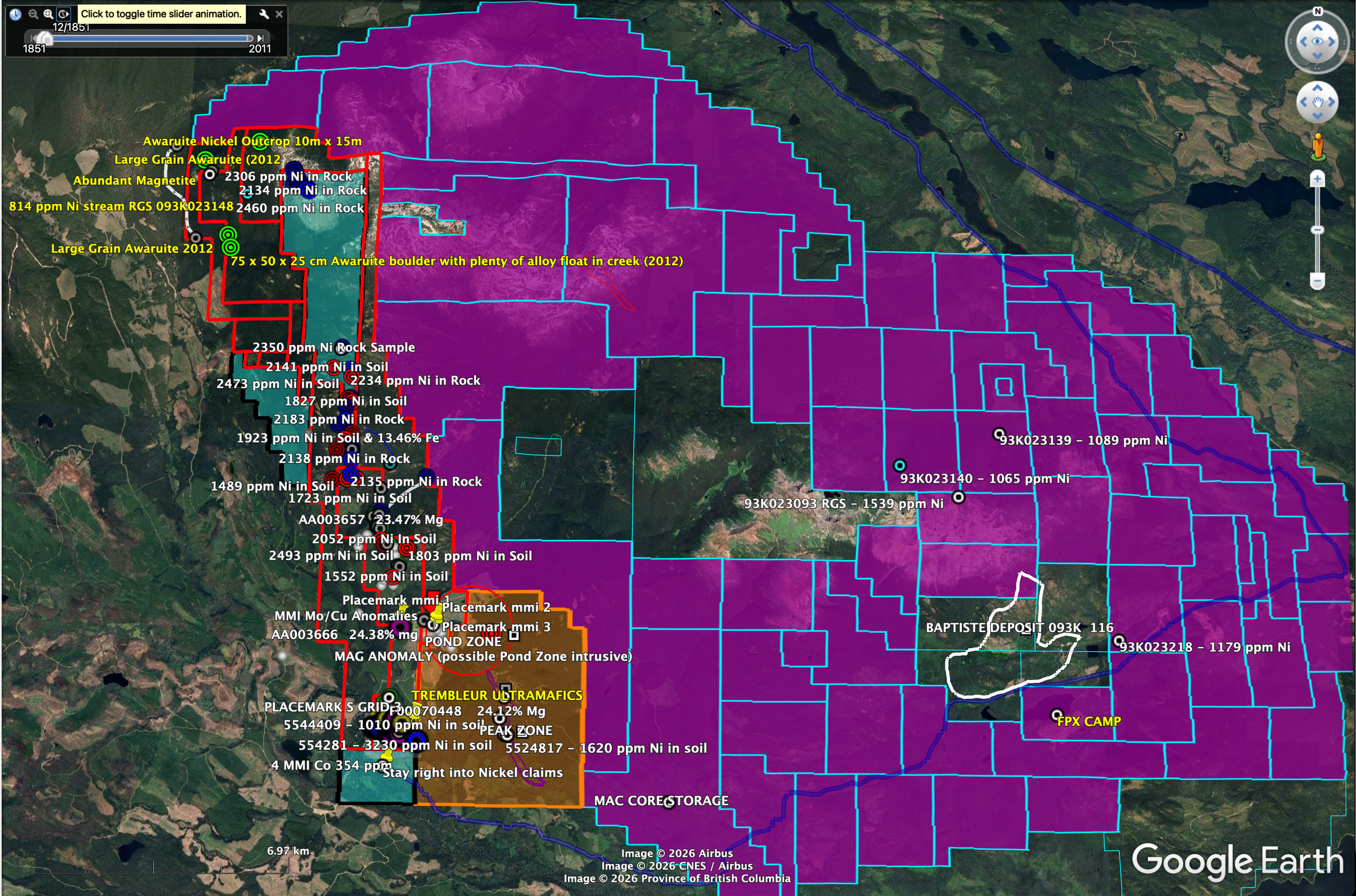
The 5620-hectare Mac Nickel Property is a prime exploration site, hosting a significant ultramafic rocks like FPX Nickel’s Baptiste Nickel Deposit, one of Canada’s largest nickel resources. The MAC Nickel claims are outlined in RED.
MAC Nickel Property is Available for Option
Nickel (awaruite), Cobalt Prospect - (5260 ha) 13,887 acres
MAY & JENNIE GOLD
High-Grade Gold Deposit - Located on 2 Mineral Leases near Nelson, BC

Despite an Indicated Resource of 80,000 tonnes @ 8.57 gpt Au (21,094 oz) blocked out in the late 1800s, the deposit was never mined. In 1986 Player Resources exposed mineralization at surface for 345m.
In 2018, BC Mining Properties exposed mineralization on the May & Jennie mineral leases for approximately 600m at surface where it remains open in three directions.
Underground, mineralization varies from 1.52m to 7.32m wide for an average width of 4.25m and depth of at least 71.6m according to historical reports.
The May & Jennie gold mineralization has always been interpreted as a vein deposit. BC Mining Properties believes that the May & Jennie mineralization may be part of a stratabound deposit pushed into multiple vertical folds, spaced approximately 80m apart. If this holds, it sets the stage for the possibility of a much larger deposit than would otherwise be the case.
Assuming the mineralization averages a 1-meter width, to a depth of 200m, the existing resources will exceed 106,000 ounces of gold. At 4m width (which is less than the average width according to historical reports) the numbers equate to approximately 424,000 ounces of gold at 10 gpt Au.
The property is permitted through the 2024 Mining Season for drilling and trenching along with the removal of up to 925 tonnes. Approximately 75 tonnes have been removed to date averaging more than an estimated 10 gpt Au +/- with a single pass of grinding and processing through a Falcon 400 concentrator with approximately 50% recovery. Much of May & Jennie’s gold is also retained in black sand (magnetite). A one-gallon pail of this black sand collected from Fconcentrator tailings, assayed 256 gpt (8.23 opt) Au.
The Red Top is an important 2nd wave (possible fold) of mineralization comprised of a low-grade structure located above the May & Jennie and has been interpreted to extend > 44m +/- wide. Depth is undetermined because of poor exposure and limited work. If the structure strikes as interpreted from a 1984 VLF geophysical survey, and extends to 200m in depth, the area could easily double the current May & Jennie gold resource.
A recent assay taken from the Upper Red Top returned 5.373 gpt Au, 927 ppm W, 301 ppm Co, 29.82% Fe, 17ppm Bi. A second assay from the same 631-gram sample returned 1.879 ppm Au indicating the presence of nugget-effected free gold. The VLF geophysical survey seen on the next page, also indicates the possibility the structure may be of significant size.
MAY & JENNIE GOLD - LEARN MORE
BONAPARTE GOLD PROPERTY
HIGHLY Prospective Au + Cu/Au Porphyry Prospect
Optioned - Decade Resources Ltd.
Decade Resources Ltd. - Option to acquire an 80% Interest
802213 Alberta Ltd. - retains a 20% carried Interest
Recent MMI soil geochemistry has identified a large, multi-element anomaly spatially coincident with historical IP chargeability highs, supporting the interpretation of a buried, sulphide-rich copper–gold porphyry system
NEWS!
Oct 30, 2025: Decade samples 1662 gpt Au (53.43 troy ounces per metric tonne) + 0.88% Cu from the Bonaparte Property
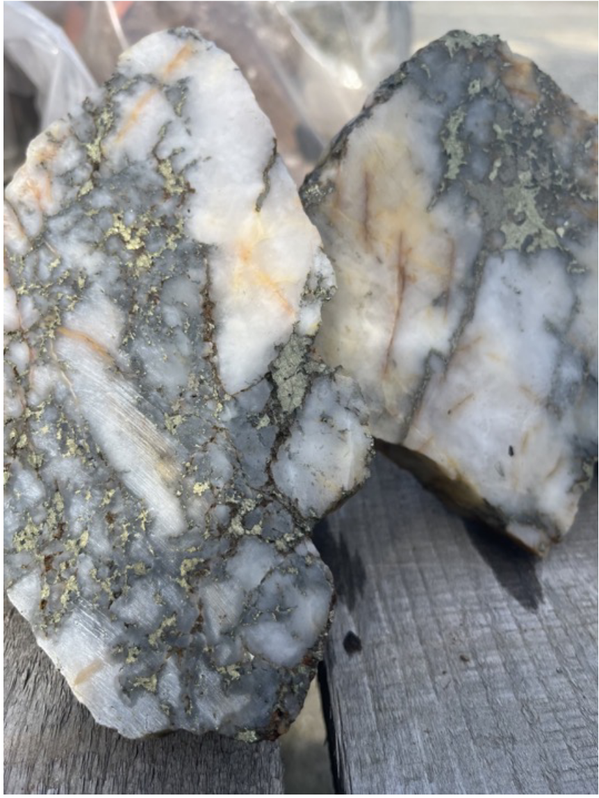
Photo of Sample asssaying 1662 gpt Gold & 0.88% Copper

Bonaparte Mine Portal - Circa 2015
BC Mining Properties is focused on two deposit types within the Bonaparte Property
The Bonaparte Property also has two deposit types. The 1st is Copper-Gold (Cu-Au) Porphyry.
BC Mining Properties believes the potential of Bonaparte may never be fully-arealized until it can be explored for its Cu-Au porphyry potential through drilling.
Initial sampling and analysis indicate copper in higher grades and proportions than typically discussed in historical reports. The theory is the copper and gold seen in the upper diorite quartz system had to come from somewhere and may be part of a secondary dispersion from a large high-grade porphyry system seen at depth in geophysics before being emplaced alongside and atop to form the younger Discovery Zone.
This is supported by compelling geophysical data indicating more than one intrusive body at depth with a large overlapping area of high chargeability and low resistivity situated 1 km South.
The thinking behind the Discovery Zone & Cooler Creek Trend…
Faults or fractures could serve as pathways for hydrothermal fluids, which can transport and deposit metals such as copper and gold. The mineralization and geochemical anomalies may indicate that such structures are extensions of a buried porphyry system located partially under an overlying basalt cap.
**Hidden Extensions: ** The geophysical anomalies (low resistivity and high chargeability) near the basalt cap might represent a porphyry copper system's core or main body. The geochemical anomalies in the NE (Discovery Zone and the Cooler Creek Trend) could be the distal expression of this system, where mineralization has been remobilized along structural features extending out from the main deposit (i.e. Cooler Creek and the Discovery Zone.
Geophysical data indicates the larger southerly body begins near the surface and gradually increases in size to approximately 3 km wide x 2 km length at approximately 275m depth then gradually decreases in size to a depth of 500m, which is the extent of the data.
The 2nd deposit type is Shear-Hosted Gold (Au) in Quartz Veins.
To date, Bonaparte’s Discovery Zone has only been explored for high-grade gold resulting in two bulk sample programs intended to effectively high-grade gold from 8 quartz veins near the surface. Approximately 103 kg of gold has been recovered from 4064 tonnes milled (25.58 g/t Au). Many anomalous zones and features for Discovery Zone style gold vein targets extending south and east and underlying historical geochemical and geophysical results completed in 2013/14, all remain unexplored. In 2015, the first drill hole drilled outside of the Discovery Zone intersected a 1.0m interval of 7.88 gpt/Au and has also never been followed up with additional drilling. This newly discovered vein (#9) and intersection attest to the potential of discovering additional gold-bearing quartz veins along the Cooler Creek trend. Most of the historic drilling never extended much below 55m depth.

BONAPARTE - LEARN MORE
HERE IS A LINK TO A RECENT AI GENERATED DEEP-DIVE ANALYSIS INTO THE BONAPARTE GOLD PROPERTY. ITS A GOOD READ!
In addition to the Mo-Cu Deposit, the west side of the MAC Property hosts the same rocks and geology as FPX Nickel’s Baptiste Deposit.
This nickel, chrome, magnesium and cobalt corridor, with a strike-length in excess of 16 km, represents a significant (undrilled) exploration opportunity as follows:
THE MAC NICKEL PROPERTY
An Awaruite Nickel System
Geological Interpretation
The MAC Nickel Project is interpreted as a fault-displaced segment (~8 km lateral offset) of a regional serpentinized ultramafic package known to host awaruite-style nickel mineralization. Regional magnetic and geophysical datasets document fault displacement of this magnitude, supporting preservation of the original lithological and metallogenic architecture despite structural offset.
Technical Evidence
Multiple independent datasets support the interpretation of MAC as a preserved awaruite nickel system:
Major Structural Offset:
Regional magnetics and geophysics indicate ~8 km of lateral displacement along a major fault, consistent with documented regional tectonics and restoration of ultramafic units.Ultramafic Host Rocks:
Rock samples containing ~23–24% Mg confirm serpentinized ultramafic lithologies typical of awaruite-bearing systems.Confirmed Awaruite Mineralization:
Awaruite (Ni–Fe alloy) has been directly identified throughout the property in bedrock samples, confirming the deposit model.Coherent Nickel–Cobalt Geochemical Footprint:
Mobile Metal Ion (MMI) geochemistry defines a strong and coherent nickel anomaly (up to ~11,900 ppb Ni) with supportive cobalt responses, consistent with dispersion from a rooted ultramafic nickel source.Established Processing Pathway:
FPX Nickel Corp. has demonstrated production of battery-grade nickel sulphate with cobalt by-products from awaruite concentrate, substantially de-risking downstream processing for comparable awaruite systems such as MAC.
Why This Matters
MAC Nickel represents a structurally displaced but preserved slice of a proven awaruite nickel system, where commodity risk and metallurgical uncertainty have already been materially reduced through extensive work completed by FPX Nickel. The remaining uncertainty relates primarily to geometry, thickness, and continuity, rather than the validity of awaruite as a nickel source or its processing viability.
Next Steps
Planned work includes first-pass drilling (~200 m drill holes) designed to confirm ultramafic continuity at depth, characterize awaruite abundance, and evaluate grade distribution and geometry.
OMINECA-ABE PROPERTY
Cu - Au Porphyry Prospect
REPORTS
ARIS REPORT 29914 (2007 Drill Program)
ARIS REPORT 39621 (2021 Geochem Program)
THIS PAGE IS EMERGING SO PLEASE CHECK BACK AGAIN SOON
THUNDER COPPER PROPERTY
Cu - Au Porphyry Prospect
REPORTS
THIS PAGE IS ALSO EMERGING SO PLEASE CHECK BACK AGAIN SOON


ARIS REPORTS, PROPERTY FILES ETC.
EMPR AR *1935-F26-28; 1937-F35
EMPR ASS RPT *12279, 13492, 13942, 14615, *15831, *16873, 22740, 37877
EMPR BULL 81
EMPR FIELDWORK 1992, pp. 37-52
EMPR GEOS MAP 2002-03
EMPR PF (Unknown [unknown]: Air Photo Overlays - Vic Claim; Unknown [unknown]: Claim Map - Vic and Num 1-3 claims; Unknown [unknown]: Lineament Analysis Map - Nechako Basin Project; Nemco Explorations Ltd. [unknown]: Plan of Back Side of Vic 11th - Trenches:Geophysics:Assays:Soil Grid - Vic Gold Property; Silver Standard Mines Ltd. [unknown]: Sample Location Map - Modified Plan of Map in 1935 Minister of Mines Report - Vic; unknown [unknown]: Sampling Notes - Vic; unknown [unknown]: Sketch Map - West Side - Vic Claims area; unknown [unknown]: Sketch Section - Structure and Sampling – Vic; unknown [unknown]: Sketch Section - Vic; unknown [unknown]: Sketch Section – Vic (II) ; unknown [unknown]: Sketch Map - Vic (II); *V. Dolmage [1936-02-05]: Report on the Vick Gold Property; *N.G. Cornish [1958-09-15]: Preliminary Report on "Vic Group" Property; unknown [1960-04-04]: Claim Map - Taseko Lake Area; Nemco Explorations Ltd. [1974-11-11]: Section - Looking NW - Vic Gold SHWG; *G. von Rosen [1974-11-11]: Plan U/G and SFC - Vic Gold SHWG; Nemco Explorations Ltd. [1974-11-26]: Progress Reports - Nov. 26, 1974 - Vic Gold Property; *Nemco Explorations Ltd. [1974-11-28]: Progress Report - Nov. 28, 1974 - Vic Gold Property; G.E.A. von Rosen [1975-11-14]: Progress Report - Nov. 14, 1975 - Vic Gold Property; New Pyramid Gold Mines [1975-12-29]: Sample Plans, Drill Logs and Assays - 1974-1975 - Vic; H.V. Warren [1976-04-28]: Letter Re: Examination of Drill Core; Cop-Ex Mining Corp. Ltd. [1976-07-23]: An Exploration Report on the Vic Claim Group; Cop-Ex Mining Corp. Ltd. [1976-08-04]: News Release to Shareholders: Taseko Lake Gold, Silver, Copper Property; *Cop-Ex Mining Corp. Ltd. [1976-08-17]: Notes and Assay Certificates - Packsack Holes - Taseko Vic Claims; unknown [1976-08-30]: Notes RE: Call from Tony Kostuk - Vic; T.C. Keefer [1977-11-15]: Letters Re: Gilford Resources Ltd. Vic Claim Group, Taseko Lake Area; A.F. Reeve [1977-11-17]: Diagramatic Sketch Section - Looking NW - RE Data & Discussion with R. Westervelt - Vic Prospect; A.F. Reeve [1977-11-22]: Letter Re: Vic Gold Prospect, Taseko Lakes District, British Columbia: Exploration Proposal to Peyto Oils Ltd. by Kershaw and Zuber; Gilford Mines Ltd. [1977-11-24]: Summary Report on Vic Gold Holdings; Stryker Resources [1980-08-26]: Certificates of Assay - No. 8009-1251, A83118 - Vic; M.K. Lorimer [1983-06-10]: Engineering Report on the Vic Property; Stryker Resources Ltd. [1980-12-03]: Summary Report on "Vic" Gold Property; Sunmark Mines Ltd. [1984-05-25]: Summary Report - Vic Gold Property; A.C.N. [1985-05-01]: Magnetometer Survey - Vic; Stryker Resources Ltd. [1986]: Geophysical Report on the Vic Mineral Claim; Kingsvale Resources Ltd. [1987-03-19]: A Summary Review Report on the Vic Property; Kingsvale Resources Ltd. [1987-04-30]: Press Release - Kingsvale Resources - Vic; unknown [1987-07-11]: Field Notes - Kingsvale FMC - Vic Property; Kingsvale Resources Ltd. [1987-10-01]: Resume of Exploration Work Carried Out By Kingsvale Resources Ltd. In 1987 On The Vic Gold Property; Kingsvale Resources Ltd. [1987-10-01]: Preliminary Plans - Gold Occurrences and Gold Geochemical Anomalies - Vic Property; C. Hrkac [1987-11-01]: Mapping and Sampling of the Cliff Area on the Vic Claims; Kingsvale Resources Ltd. [1988-02-01]: Preliminary Plans - Gold Occurrences and Gold Geochemical Anomalies - Vic Property (Revised); Kingsvale Resources Ltd. [1988-02-19]: Prospectus Report on the Vick Gold Property; *Stryker Resources Ltd. [1988-10-01]: Geological and Geochemical Report on the Vic Property)
I HIGHLY ENCOURAGE REVIEWING THE PROPERTY FILES LISTED BELOW TO GET A SENSE OF THE POTENTIAL OF THIS PROPERTY
EMPR PFD 903317, 13250, 13251, 13253, 826407, 680423, 680769, 681033, 681034, 681035, 681036, 681037, 681038, 681039, 681040, 681042, 681043, 681044, 681045, 681046, 681047, 681048, 681049, 681050, 681051, 681052, 681053, 681054, 681055, 681056, 681057, 681058, 681059, 681060, 681061, 681062, 681063, 681064, 681065, 681066, 681067, 681068, 681069, 681096, 681097, 681098, 681099, 681100, 681101, 681102, 681103, 681104, 681105, 681106, 681107, 681108, 681109, 681110, 681111
EMR MP CORPFILE (New Pyramid Gold Mines Inc.)
GSC OF 534; 2207
CMH 1940, p. 134
VIC GOLD IS AVAILABLE FOR SALE OR OPTION
NEW
BREN / KENO PORPHYRY
PROPERTY SIZE: 355.68 ha (879 Acres)
MINFILE No 093A 079
The Bren - Keno occurrence is located south of Horsefly Mountain at an elevation of approximately 1200 metres, on the north side of the Horsefly River Valley between Club Creek and the east fork of Black Creek.
Regionally, the area lies near the eastern margin of the Upper Triassic Nicola Group marine sedimentary and volcanic assemblage. The lowermost volcanic rocks consist of alkali basalt and alkali olivine basalt that, in this area, have been intruded by quartz porphyry dikes. These have been intruded by bodies of Late Triassic to Early Jurassic dioritic to syenitic rocks.
Locally, a thick sequence of northwest-striking, southwest-dipping mafic volcanic tuffs and flows(?) with intercalated argillites have been intruded by multiple apophyses of intrusions consisting of (biotite-quartz, feldspar-biotite and quartz-feldspar-biotite) monzonite, syenite, pyroxenite and porphyry and aplite dikes with local contact metasomatic zones. The contact zones are silicified and sericitized with minor epidote, chlorite and biotite and contain widely spaced, generally narrow but up to 2-metre wide, quartz-calcite veins with disseminations and veins of pyrite, pyrrhotite, arsenopyrite, chalcopyrite and sphalerite. Gold mineralization is associated with massive sulphide, primarily arsenopyrite, veins up to 40 centimetres wide. Semi-massive pyrite mineralization with minor chalcopyrite is present for greater than 2 metres in a heavily sheared zone adjacent to some of the quartz veins. Mineralized veins have been identified, intermittently, over an area of 250 metres east-west and 100 metres north-south.
Diamond drilling has identified widespread molybdenite mineralization as fracture coatings and disseminations in all units cored and related to an argillic-pyritic alteration zone beneath a silica capping characterized by a pyrrhotite-chalcopyrite-actinolite stockworks. An area or layer of ferricrete is also reported capping and/or associated with the mineralized zone. Drilling and trenching indicate a possible metal zoning of a copper-molybdenum-tungsten mineralized core with an outer halo of gold-associated arsenopyrite mineralization and peripheral fringe of lead-zinc-silver mineralization.
In 1983, rock samples of narrow mineralized veins exposed by an area of trenching yielded up to 14.9 grams per tonne silver, greater than 10.0 grams per tonne gold and 1.00 per cent zinc (Assessment Report 12363).
In 1995, a sample of mineralized ferricrete exposed by a new roadcut is reported to have assayed 1 per cent molybdenum, 0.30 per cent copper, 0.08 per cent tungsten and 0.44 gram per tonne gold (Assessment Report 25734).
In 1996, a grab sample (BF-96-07) of mineralized vein material from a past trench assayed 32.8 grams per tonne gold, 55.4 grams per tonne silver and 4.6 per cent zinc, whereas a 5.0-metre chip sample (BF-96-06) from the trenched area assayed 1.06 grams per tonne gold (Assessment Report 24717). Also, at this time chip sampling of new trenches (TR96-01), west of the past trenches, yielded 0.11 gram per tonne gold over 20 metres (Assessment Report 24717).
In 2000, diamond drilling intersected a molybdenum-bearing porphyry system yielding 0.021 per cent molybdenum over 59 metres in hole K-2 and 0.032 per cent molybdenum over 87 metres in hole K-3 (Assessment Report 26317).
In 2008, resampling of two quartz-molybdenite mineralized sections of drillcore from hole K-3 yielded values of 0.077 and greater than 0.200 per cent molybdenum with 121 and 943 parts per billion rhenium, respectively (Assessment Report 30356).
In 2012, sampling of trenches from the silica cap zone yielded up to 0.37 gram per tonne gold with elevated values of copper and molybdenum, whereas trenching on an 80-metre long oxidized saprolitic gossan zone, in excess of 8 metres deep and located along a granodiorite-silica cap contact, yielded up to 0.311 per cent copper, 0.014 per cent molybdenum, 22 grams per tonne silver and 0.83 gram per tonne gold (Assessment Report 33259). Also, at this time, a sample (K190655) from the former ‘Bren’ (Glory Hole) trenches of gold-bearing arsenopyrite mineralization assayed 16.6 grams per tonne gold, 16 grams per tonne silver and 0.163 per cent zinc (Assessment Report 33259).
In 1973, the first documented activity refers to the gold-bearing sulphide veins, which were probably discovered by logging operations of the time. The prospect was subjected to trenching (457 metres), soil sampling (22 line-kilometres) and magnetic surveying (14 line-kilometres).
In 1982, geochemical sampling indicated the presence of anomalous gold associated with sulphide mineralization. In 1983, the property was restaked by Selco (BP Exploration Canada Ltd.) as the HR 1-5 claims and 17.7 kilometres of grid work was completed consisting of soil sampling at 200-metre intervals and rock chip sampling of the old Bren trenches. In 1990, Noranda Explorations soil sampled the area immediately west as the Tacoma claim.
In 1995, the area was staked as the Keno claims by owners H. Wahl and J. Brown-John based on the discovery of high-grade ‘mineral’ occurring within ferricrete exposed by new road building. In 1996, the claims were optioned to Westmin, who completed a trenching program that failed to penetrate the ferricrete zone; the claims were subsequently returned. In 1997 and 1998, the owners completed 1 kilometre of induced polarization surveying across the existing zone and conducted prospecting with soil and rock sampling. In 2000, the owner-operators completed four drillholes, totalling 603.5 metres; two holes intersected molybdenite mineralization and bottomed in mineralization at 127 metres.
In 2006, the owner-operators conducted line cutting and a soil geochemical and geological reconnaissance survey focused on outlying areas from the molybdenum zone. In 2008 and 2011, further programs of soil sampling and prospecting were completed on the Keno claim. Also, during 2010 through 2012, Bullion Gold Corp. completed programs of soil sampling, 45.5 line-kilometres of induced polarization surveying and 1874.0 line-kilometres of airborne geophysical surveying on the surrounding area as a part of the Cariboo Goldfields and Horsefly properties.
In 2013, Woodjam Horsefly Resources Ltd. completed a program of soil and rock sampling and 1073 metres of trenching.